Using OSM FieldPapers
Motivation
CCTV surveillance cameras have been widely installed by governments and businesses with the goal of enhancing public safety. As storage and data processing become less expensive and more available, there are real concerns about data retention and the use of automated facial recognition schemes to track people as they go about their day.
In addition to the government managed networks, there has been an explosion of doorbell cameras installed at residences by companies like Wyze and Amazon's Ring. The EFF has written at length about some of the privacy concerns with Ring in particular.
Public knowledge of how widespread cameras are and how they're used is critical for having an informed policy discussion about the tradeoffs in a person's right to maintain privacy and crime prevention. The Massachusetts Pirate Party and the Boston Institute for Nonprofit Journalism (BINJ) have been collecting the locations of installed cameras for several years now. They have been registering the locations of the cameras that they have found in an open database called OpenStreetMap (OSM).
OpenStreetMap (OSM) is a freely editable map of the world. I'm sure that some services that you're using are pulling data from this project. In New England, much of the data in the map comes from government GIS projects. Those data provide a good base on which to add businesses, shops, parks, roads, streetlights, and trees, among other things.
The first step in adding data to the OSM database is to find out where things are in the real world. You can use a GPS to save the locations of things, edit the OSM database directly using a smartphone application, or print out some paper maps to mark up as you walk along.
In this short tutorial, we'll go over one possible workflow for adding new data to the OSM database. A high level overview of the workflow is:
- Decide where to map
- Print some paper maps of the areas
- Walk around looking for items of interest
- Add them into the OpenStreetMap Database
Decide where to map
I suggest looking around your neighborhood for cameras which on your normal walks. Bring some paper maps with you to take notes on. In addition to mapping cameras, map other characteristics of your neighborhood as well.
I would stick to mapping things that are easily visible from public places, unless you have permission from the property owner.
Making Maps
Different services exist to turn the OSM data into a paper map, but I prefer FieldPapers. Unfortunately the project seems to have gone a bit dormant. As of today (<2020-09-09 Wed>), the webapp still works well, though the SSL configuration is invalid. Due to this, I would skip creating an account and just use the site as-is.
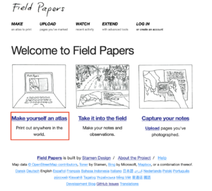
To get started, open the FieldPapers site and click on the "Make yourself an atlas link". I've highlighted it in red in the screen capture.

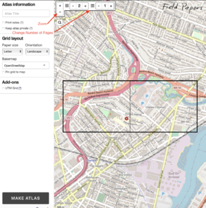
The following screen will allow you to zoom into the area of interest. Click and drag to move the map, and use the zoom in and out buttons to find an area of interest. For this tutorial, I've selected part of a small city in the Boston area. When you're happy with the map placement, you can change the number of pages in both the horizontal and vertical directions that the map will split into. If you will be mapping as part of an event, it's convenient to create small areas for groups of people to canvass. You're also able to select if the map will print in landscape or portrait mode. This can help better fit areas into the map. You're also able to change the tileset used to render the maps - depending on the area you're in, this may be a helpful thing to do.

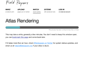
In this case, I've broken up the area into eight pages. Press the "Make Atlas" button when the map is to your liking and be patient while the server creates the PDF file.

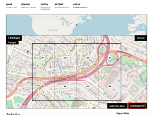
When the rendering is complete, you can press the "Download PDF" button and print your map.

In the Field
Now that you have a paper map, go for a walk in the area of interest and take some notes. Write down the locations of any interesting stuff on your map. The notes don't need to be perfect, but hopefully enough to fill in any necessary metadata. For cameras, the following metadata types are defined:
Surveillance Kind (Indoor / Outdoor (on private property) / Public)
Surveillance type (Is it a camera, Automated License Plate Reader or other device?)
Camera Type (Fixed Camera, Pan/Tilt/Zoom, Dome Camera?)
mounting (What is the camera mounted onto?)
Operator (Who owns the camera?)
OSM has a nice wiki which describes the objects which have metadata defined. The
surveillance camera article is here.
Feel free to come up with your own notation on how to mark up the maps.
Back in the Office
Back in the office, log into OpenStreetMaps. FieldPapers is capable of generating some neat tagged image files which certain map editors can use, but those editors can be a bit fiddly to setup. The browser based ID editor is quite easy to use, so I would suggest using that.
A succinct tutorial on using the OSM project's web-based ID editor is located on this wiki:
Mapping Cameras with OpenStreetMap's Web UI
Other Resources
* https://github.com/ucdavisdatalab/workshop-field-papers

* https://medium.com/binj-reports/binjbrother-c1bec615a026#.avwuyfswx
* https://resiliencymaps.org/how-to-run-an-openstreetmap-mapathon-using-field-papers
* https://learnosm.org/en/coordination/mapathon/
* https://www.missingmaps.org/assets/downloads/mapathon-materials/english/How_to_Host_a_Mapathon_EN.pdf